Geography has never been just about maps. It is the study of how space, place, resources, and human activity shape power, opportunity, and survival. This lesson explores how geography evolved from a physical discipline rooted in the land to today’s dynamic field of Digital Geography — and what that transformation teaches us about navigating the world in 2026 and beyond.
The Foundations: Geography as Strategy
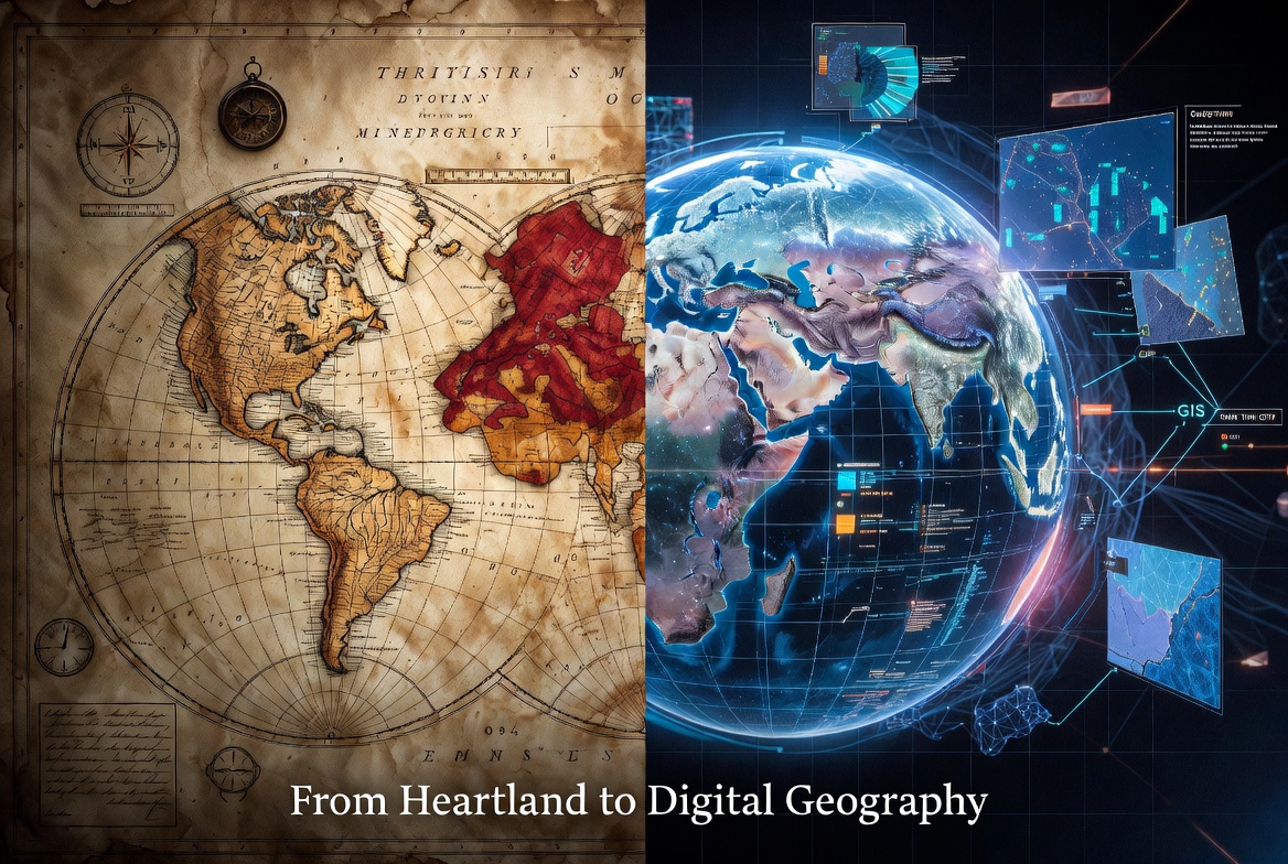
In 1904, British geographer Sir Halford John Mackinder delivered his landmark paper, “The Geographical Pivot of History,” to the Royal Geographical Society. He argued that control of the vast Eurasian “Heartland” — the interior of Europe and Asia — would determine global dominance in the industrial age. Railroads, not just navies, would decide the future.
Mackinder’s Heartland Theory was more than an academic theory; it became a lens through which generations viewed geopolitics. It illustrated a core truth: geography shapes destiny.
Even earlier, geography served as a practical tool for survival and discovery. In 1854, physician John Snow mapped cholera outbreaks in London and traced the source to a single contaminated water pump — one of the first documented uses of spatial analysis to solve a real-world crisis. Ancient civilizations relied on rudimentary maps for trade routes, conquest, and agriculture. These analog lessons showed that understanding “where” things happen is the foundation of strategy.
The Digital Turning Point
The 20th century brought the first major leap: computers and data.
In 1963, Canadian geographer Roger Tomlinson created the world’s first true Geographic Information System (GIS) while helping inventory Canada’s natural resources. For the first time, maps could be layered with multiple data sets — population, terrain, climate, infrastructure — and analyzed by machines.
The U.S. Census Bureau digitized its maps. Companies like Esri commercialized GIS software. The 2000 opening of civilian GPS, combined with satellite imagery and the internet, brought digital mapping to everyday life through tools like Google Maps and OpenStreetMap.
Geography had moved from static paper charts to dynamic, searchable, data-rich systems. What once required weeks of fieldwork could now be explored in seconds.
Digital Geography Today
In 2026, Digital Geography is defined by intelligence, real-time insight, and integration:
- GeoAI (Geospatial Artificial Intelligence) merges machine learning with satellite, drone, and sensor data to detect patterns humans cannot see — from changes in farmland health to urban heat islands or supply-chain disruptions.
- Digital Twins create living 3D virtual replicas of cities, infrastructure, or entire regions, allowing us to simulate floods, traffic patterns, or market shifts before they occur.
- Cloud + IoT Convergence feeds continuous data from sensors and satellites into cloud platforms, turning maps into living, updating models.
- Immersive Mapping uses advanced visualization (including 3D and semantic awareness) to make complex spatial data interactive and predictive.
Today, we no longer simply ask “Where?” We ask: What is happening there right now? Why is it changing? What will happen next?
Key Lessons for the Future
This evolution offers four enduring lessons:
- Physical geography still matters — it is simply amplified. Location, climate, resources, and proximity continue to drive economics, security, and daily life. Digital tools make these factors more visible and measurable than ever.
- Data layered on a place creates new forms of power. Combining historical context with real-time geospatial intelligence allows better decision-making in planning, resilience, and sustainability.
- Technology demands responsibility. As GeoAI and digital twins grow more powerful, we must address critical questions around data privacy, algorithmic bias, equitable access, and environmental impact.
- The next “pivot of history” is digital. Just as Mackinder identified the strategic importance of the Heartland in the railroad era, today’s world requires us to understand how digital geography reshapes resilience, opportunity, and global interconnectedness.
The story of geography is one of continuous adaptation — from clay tablets and hand-drawn charts to satellite constellations and AI-powered twins. Those who study both its deep historical roots and its cutting-edge digital forms will be best prepared to understand and shape the world ahead.
Alan J. Mackinder is Senior Strategist at Mackinder Strategies. A U.S. Marine with deep expertise in geopolitical analysis and digital strategy, he helps leaders navigate uncertainty with data, history, and foresight.